Earthquake Hazard Information – Hazard, Risk,
Magnitude, Intensity, Earthquake Statistics – Part 2 (Information for
interpreting the results of building contest and shake table testing; L.
Braile,
Earthquake Hazards: The US Geological Survey recently released a
publication (Fact Sheet 017-03, http://geopubs.wr.usgs.gov/fact-sheet/fs017-03/,
shown below) that discusses various aspects of earthquake hazard assessment in
the

U.S.
Fact Sheet 017-03
The USGS Earthquake Hazards Program in NEHRP—Investing in a Safer Future
|
In
1977, Congress authorized the creation of the National Earthquake Hazards
Reduction Program (NEHRP) to improve the Nation’s understanding of earthquake
hazards and to mitigate their effects. Earthquakes are the most costly
natural hazard faced by the |
|
|
|
As
shown by this U.S. Geological Survey (USGS) national seismic-hazard map,
earthquake hazards exist throughout the |
The U.S. Geological Survey (USGS) Earthquake Hazards Program monitors the Nation’s earthquakes, studies why they occur and how they shake the ground, provides quantitative earthquake-hazard assessments, helps promote loss-reduction measures using these results, and provides crucial scientific information to assist emergency responders when earthquakes occur. The USGS Earthquake Hazards Program operates under the National Earthquake Hazards Reduction Program (NEHRP), created by Congress in 1977. To meet the challenges and potential of NEHRP, activities supported by the USGS Earthquake Hazards Program are managed under four broad interrelated objectives:
• Improve quantification of seismic hazards—The USGS produces quantitative hazard-assessment products that enable the public and private sectors to assess earthquake hazards and implement effective mitigation strategies.
• Complete the modernization and expansion
of real-time earthquake notification and monitoring systems—The USGS is tasked
with collecting, interpreting, and disseminating information on the earthquakes
that occur throughout the
• Achieve better scientific understanding of earthquake processes and effects—The USGS pursues research on earthquake occurrence and effects for the purpose of developing and improving hazard-assessment methods and loss-reduction strategies.
• Provide national and local leadership to engage communities in earthquake safety practices—The USGS works with user communities to ensure that its products are readily available, easily understood, and appropriately used for earthquake mitigation and response.
The work of the USGS Earthquake Hazards Program focuses both on the Nation as a whole and also on particular regional needs and problems in areas where quake risk is the greatest. The program’s work is carried out by USGS scientific and technical personnel and also through a system of competitive external grants and contracts that is allotted one-quarter of program funds. In the past 25 years, this grants program has funded approximately 2,500 grants and cooperative agreements with state geological surveys, university researchers and research consortia, state and local government agencies, and nonprofit and other organizations in the private sector. USGS also works closely with the other NEHRP agencies (FEMA, NSF, and the National Institute of Standards and Technology) and with non-NEHRP agencies, such as NASA, NOAA, and USAID.
Accomplishments and Impacts of the USGS EarthquakeHazards Program
Over the past 25 years, NEHRP has made the
Nation safer from the ravages of earthquakes. One of the flagship products from
NEHRP contributing to this achievement are the national seismic-hazard maps
that the USGS has produced since 1976. These maps are derived by estimating the
likelihood of future earthquakes along active faults throughout different
regions and evaluating the ground shaking that these quakes would cause. These
seismic-hazard maps are the scientific basis of seismic provisions in building
codes enacted throughout the
The national seismic-hazard maps are also used in FEMA’s retrofit guidelines, ensuring that older buildings are strengthened so that they withstand future earthquakes. In addition, these maps and associated products are used in the design of highway bridges, landfills under EPA regulation, and dams, as well as in the setting of earthquake-insurance premiums and the cost of reinsurance. The California Earthquake Authority uses seismic-hazard maps produced jointly by the USGS and the California Geological Survey to set earthquake premiums for the State’s quake-insurance program. Pension funds apply these maps to evaluate the risks to their portfolios of properties. Presidential executive orders specify that new and leased Federal buildings must adhere to the NEHRP Recommended Provisions. The State of Oregon recently raised seismic requirements in construction along the southern part of its coast, largely on the basis of information presented in the USGS seismic-hazard maps.
The advances in earthquake-hazard assessments during the first 25 years of NEHRP have their roots in pioneering USGS field, laboratory, and theoretical research focused on understanding the basic physical processes associated with earthquakes. Key breakthroughs include:
• Improved quantification of regional seismic-energy attenuation with distance from an earthquake.
• Use of Global Positioning System (GPS) stations to determine the rate at which faults are being “loaded” (stressed) by the movements of the tectonic plates that make up the Earth’s outer shell.
• Discovery and documentation of large prehistoric earthquakes through a new field of study known as paleoseismology (identifying evidence of past quakes in trenches dug across faults, in riverbanks, and from drowned coastlines).
• Use of new remote-sensing technology,
such as LIDAR
(light detection and ranging), to identify active faults in heavily
forested regions like the
• Quantification of the effects of soils and near-surface conditions in amplifying strong ground motion.
• Advances in earthquake forecasting through improved understanding of the physics of the fracture and friction of rocks in fault zones.
The USGS Earthquake Hazards Program has
also realized major improvements in its ability to provide timely and
informative earthquake reports and information. To fulfill its Federal
responsibility to monitor seismic activity in the
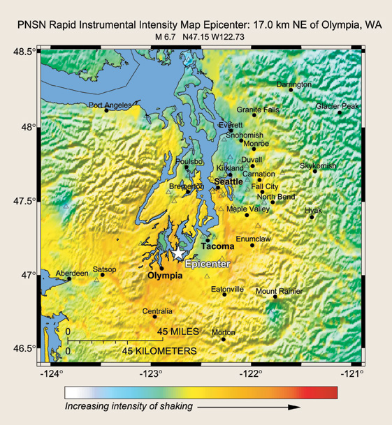
USGS has capitalized on the revolution in information technology to achieve dramatic advances in real-time seismic-data analysis and rapid earthquake notification. The most noteworthy result of this is “ShakeMap,” a system for automatically generating, within minutes of an earthquake, maps of areas subjected to strong shaking. ShakeMap, where available, can be delivered in 10 minutes or less and thus forms the basis for emergency response by cities, states, Federal agencies, and lifeline operators.
|
“SHAKEMAP”—A NEW TECHNOLOGY TO AID EMERGENCY RESPONSE |
|
|
|
This
U.S. Geological Survey (USGS) “ShakeMap” shows shaking intensities during the
2001 magnitude 6.7 Nisqually, Washington, earthquake, which caused $2 billion
in damage and economic losses in the Olympia-Seattle area. The capability to
automatically generate computer maps of the intensity of ground shaking and
to provide them to the public on the Internet within minutes of a quake was
developed after the 1994 |
Complementing ShakeMap are a suite of
other real-time earthquake products, such as earthquake paging and e-mail
services, real-time earthquake location maps, automatic Web pages with
information on significant events, and aftershock probability estimators.
Additionally, USGS has created a Web-based interface, called “Did You Feel
It?,” to provide Internet users with a means of reporting individual quake
experiences that are compiled into maps of ground-shaking intensity. This suite
of products provide the general public with rapid and comprehensive information
about
During the past 10 years, the demand for USGS earthquake-information products, including national and regional hazard maps and data from realtime seismic monitoring, has skyrocketed. USGS information now directly underpins local, state, and national earthquake loss-reduction and emergency response efforts.
|
HELPING THE PUBLIC PREPARE FOR EARTHQUAKES |
|
|
|
|
|
|
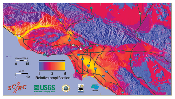
The
U.S. Geological Survey (USGS) and the Southern California Earthquake Center
(SCEC) work jointly to produce an array of earthquake-hazard products for
southern |
The Future of the USGS Earthquake Hazards Program
The USGS Earthquake Hazards Program is poised to build on its accomplishments. The USGS will continue to improve on existing earthquake monitoring, assessment, and research activities, with the ultimate goal of providing the Nation with a new generation of earthquake products that more effectively promote earthquake mitigation and better facilitate earthquake response. At the heart of this effort will be a continued emphasis on delivering information that is useful, accessible, and easily understood. By working closely with policymakers and emergency planners, USGS will ensure that they have the most reliable and accurate information possible about earthquake hazards and that USGS products are tailored to their needs. USGS will participate in local and national earthquake-mitigation planning exercises and help train emergency responders, contingency planners, risk managers, the media, and others in how to use earthquake-hazard assessments and real-time information products. USGS will also continue to interact directly with communities to help them understand their vulnerabilities to earthquakes and to plan mitigation actions. Critical decisions for earthquake preparedness and response, including those that ensure uninterrupted corporate and government operations, are often made far from areas of high seismic hazard. So that informed and appropriate actions can be taken, USGS will continue to work to ensure that earthquake-hazard information and products are useful and familiar to decisionmakers, even in regions of low seismic hazard.
|
|
|
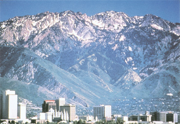
Earthquakes pose a
significant threat to urban areas in the Intermountain West. For example,
almost 75% of
The USGS is committed to providing the Nation with new and useful products to reduce earthquake losses and improve quake safety. However, many needs cannot be met or opportunities seized under current funding levels. Critical among those needs and opportunities are:
Completing the Advanced National Seismic System—A major obstacle to further reducing loss of life and property in earthquakes is the present scarcity of strong-motion recordings of actual ground-shaking levels in urban areas and of the dynamic performance of structures and lifelines in quakes. The Advanced National Seismic System (ANSS) is intended to address this need by providing a nationwide network of least 7,000 sophisticated shaking monitors placed both on the ground and in buildings, mostly in seismically active urban areas. The closely spaced ANSS stations will be used to identify areas with specific problems, such as high amplification and focusing of seismic waves, and provide data crucial for finding cost-effective seismic-design solutions.
One critical component of ANSS is the instrumentation of buildings, bridges, and other structures. It is essential to have multiple structures in high hazard areas instrumented with arrays of seismometers so that engineers can understand how different types of buildings respond to earthquake shaking. These instruments will also provide crucial information on:
• The coupling between building foundations and underlying soils,
• The role of torsion of columns in building shaking,
• The performance of commonly used structural systems, such as shear walls combined with a moment-frame structure, and
• The ability of mathematical models to predict the performance of structures during strong shaking.
|
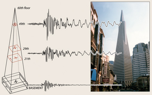
INSTRUMENTED BUILDINGS PROVIDE CRUCIAL DATA |
|
|
|
To
design safer buildings and to provide vital information for strengthening
older ones, U.S. Geological Survey earthquake engineers have installed arrays
of seismic instruments in several buildings, such as |
Another urgent need that will be addressed
by ANSS is improved reliability, timeliness, and usefulness of USGS real-time
earthquake products for emergency-response purposes. ShakeMap, in particular,
requires access to a modern seismic network with digital strong-motion
recording capabilities and real-time telecommunications feeds. Currently, few
urban areas in the
Acquiring essential data for expanded urban hazard assessments—Most current USGS earthquake-hazard assessments are compiled on regional or national scales. These estimates typically assume uniform firm soil conditions, as opposed to the varying actual soil conditions beneath cities and lifelines. At the scales required for urban planning and development, assessments need to account for the amplifying effects of soils, as well as the potential for ground failures, such as liquefaction and landslides.
USGS pilot urban assessments in
|
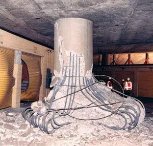
SEISMIC-HAZARD INFORMATION HELPS ENSURE THE SURVIVAL OF STRUCTURES AND LIFELINES |
|
|
|
|
|
RETROFITTED HIGHWAY OVERPASS |
NON-RETROFITTED OVERPASS |
|
U.S.
Geological Survey (USGS) seismic-hazard information is used by structural engineers
to design structures and lifelines, such as freeway overpasses, to help
ensure their survival in quakes. Over the past 25 years, USGS and other
scientists have discovered that quakes can shake the ground much more
violently than provided for in earlier building codes. The California
Department of Transportation (Caltrans) has nearly completed a program of
retrofitting bridges and overpasses throughout the State. In 1994, when the
magnitude 6.7 Northridge earthquake struck |
|

Expanding activities in the
Eastern United States—The USGS
Earthquake Hazards Program devotes approximately 75% of its resources to work
in the
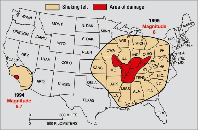
USGS studies show that urban areas in the Eastern United States face far greater damage and far more deaths in a quake of a given magnitude than those in the West for several reasons: (1) For the same magnitude earthquake, severe shaking affects a much larger area, (2) most structures are not designed to resist earthquakes, and (3) population density is high and residents are not routinely educated about seismic safety.
USGS has been developing the understanding and methods that can form the groundwork for a substantial effort in the East, where earthquake faults are rarely exposed at the surface and the subsurface conditions beneath major cities are poorly documented. More thorough and accurate assessment of the seismic risk faced by major urban centers in the East will reveal the greatest vulnerabilities and provide information that is essential to evaluating possible mitigation strategies.
|
|
|
In the
Central and Eastern United States, earthquakes are felt over a broader area
than comparable-size quakes in the |
Expanding activities in Alaska—
|
|
In. |

November 2002, the
powerful magnitude 7.9 Denali Fault earthquake struck south-central
Capitalizing on new national facilities—As described in the 2003 National Research Council report, Living on an Active Earth: Perspectives on Earthquake Science, continued progress toward evaluating earthquake hazards will increasingly require integrative, physics-based research involving theoretical studies of processes controlling earthquake phenomena, sophisticated numerical modeling, ground- and space-based field observations, and laboratory simulations. Recent and proposed U.S. Government investments in major earth-science and engineering facilities include ANSS, the NSF-coordinated EarthScope program (including the Plate Boundary Observatory, USArray, and the San Andreas Fault Observatory at Depth), the NSF Network for Earthquake Engineering Simulation (NEES), and a future interferometric synthetic aperture radar (InSAR) satellite mission. These facilities will be able to offer, for the first time, the breadth and depth of data required to truly understand the physical nature of earthquakes.
The USGS will take advantage of these new data streams to conduct earthquake-hazard-focused experiments on scales never before possible. To improve long-term hazard assessments, USGS will also use these data together with advanced computational methods to simulate the multiple factors controlling earthquakes within specific fault systems. A major goal will be to understand the criteria for the occurrence of quakes within a fault system and the impact of one quake on the system through the many processes that transfer stresses. To determine the feasibility of short-term prediction of earthquakes, USGS will build new mathematical models of quake likelihood, akin to weather-forecast models.
|
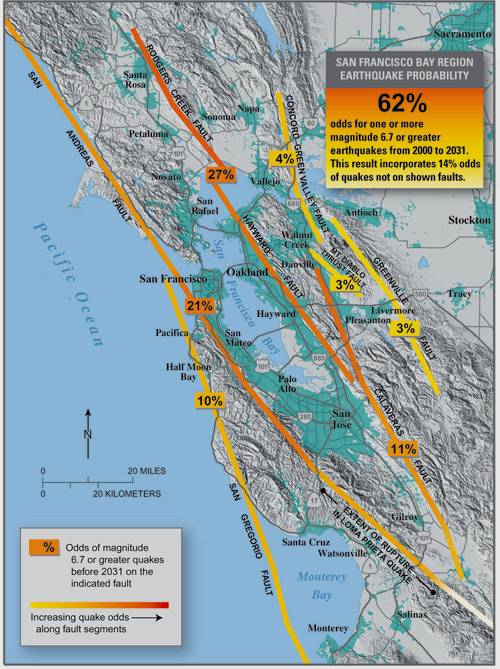
CREATING TIME-DEPENDENT EARTHQUAKE PROBABILITY MAPS |
|
|
|
Time-dependent
earthquake probability maps take into account the effects of quake occurrence
and fault interactions on the likelihood of future quakes. In 1988, the first
U.S. Geological Survey (USGS) map of this type correctly identified the future
site of the 1989 magnitude 6.9 Loma Prieta earthquake. On the basis of
research conducted since that quake, USGS and other scientists conclude that
there is a 62% probability of at least one magnitude 6.7 or greater quake,
capable of causing widespread damage, striking the |
Conclusion
After 25 years of NEHRP, the USGS
Earthquake Hazards Program is the world scientific leader in seismic-hazard
studies. In implementing the results of these studies to mitigate the effects
of earthquakes, USGS has actively collaborated with state geological surveys,
emergency-response officials, earthquake engineers, local governments, and the
public. This collaboration has resulted in dramatic improvements in earthquake
preparedness and public safety in the
By John R. Filson, Jill McCarthy, William L. Ellsworth, and Mary Lou Zoback
Edited
by Peter H. Stauffer and James W. Hendley II
Graphics by Sara Boore, Susan Mayfield, and Stephen L. Scott, and Eleanor
Omdahl
For
further information contact:
U.S. Geological Survey, Mail Stop 905
12201 Sunrise Valley Drive
Reston, VA 20192
(703) 648-6714
Visit the Earthquake Hazards Program
website to learn more
PDF version of this fact sheet (4.4 MB)
Download a copy of Acrobat Reader for free
| Help | PDF help | Geopubs main page | Fact Sheets |
| Department of the Interior | U.S. Geological Survey | Geologic Division |
| Privacy Statement | Disclaimer | Accessibility |
URL of this page: http://geopubs.wr.usgs.gov/fact-sheet/fs017-03/
Maintained by: Carolyn Donlin
Created:
Last modified: