Midwest Earthquakes
Department of Earth and Atmospheric
Sciences
http://web.ics.purdue.edu/~braile/
(March, 2004; updated April 15, 2011)
This web page: http://web.ics.purdue.edu/~braile/news/midwest.htm
http://web.ics.purdue.edu/~braile/news/midwest.pdf
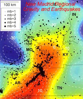
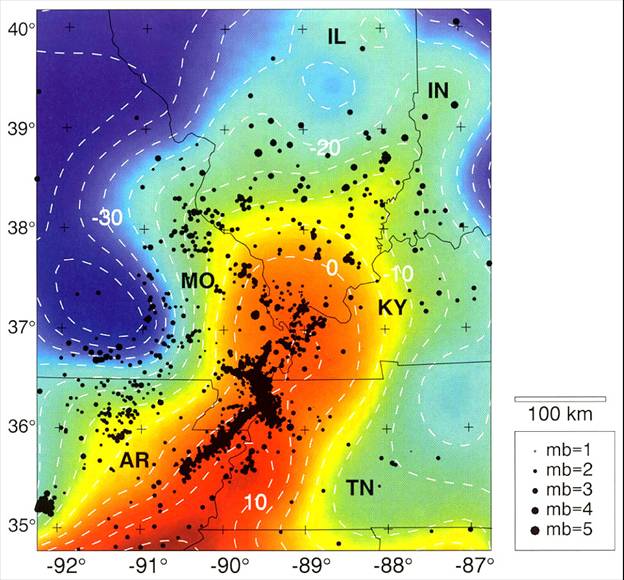
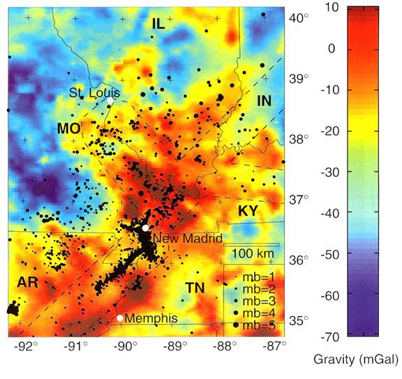
During the past three decades, earthquake data recorded by the New Madrid seismograph network (Figure 1) have provided new insight into the seismotectonics of the New Madrid seismic zone (NMSZ). Prior to the establishment of the network, the NNSZ was characterized by the less-than-200-year-duration historical earthquake record (Nuttli, 1973) and by accounts of the great 1811-1812 earthquakes (Johnston, 1982; Johnston and Schweig, 1996). Seismicity and geophysical data analyzed since 1974 have delineated prominent epicentral trends and tectonic features. Earthquake locations correlate with distinct geophysical anomalies (Figures 2 and 3) indicating that the intraplate seismicity of the NMSZ is associated with an ancient, buried rift that is currently being reactivated by the contemporary, nearly east-west compressional plate-tectonic-generated stresses (Zoback and others, 1980; Braile and others, 1982, 1986, 1997).
Positive gravity
anomalies in the upper Mississippi embayment (Figures 2 and 3) are interpreted
to be caused by high density rocks beneath the embayment that were emplaced
during the late Pre-Cambrian to early Paleozoic rifting event or during
Mesozoic reactivation of the rift.
During the past 150-200 million years, the area has subsided due to the
presence of the more dense rocks in the crust resulting in the embayment and
the deep burial of the ancient rift structure (Figures 4 and 5). Currently, the buried rift has acted as a
“zone of weakness” in the stable continental crust and serves to localize
earthquake activity within the
Recently, GPS measurements have shown that the rate of deformation in the North American continental interior and the New Madrid seismic zone is too slow to explain the earthquakes in the past 5000 years, suggesting the possibility of cycles of deformation and resulting earthquakes (Calais et al., 2005, 2006, Calais and Stein, 2009). Also, Calais et al. (2010) suggest a new model for triggering of New Madrid earthquakes by late-Pleistocene erosion.
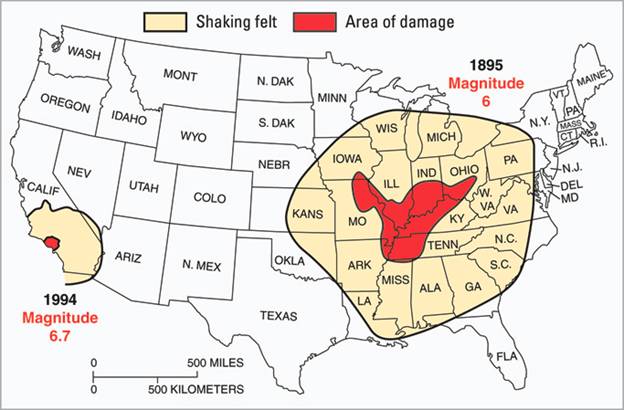
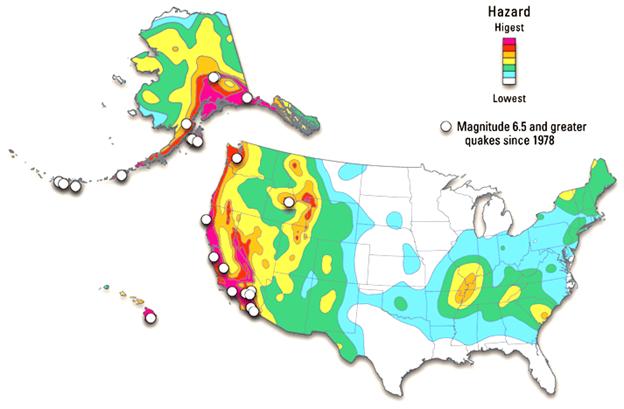
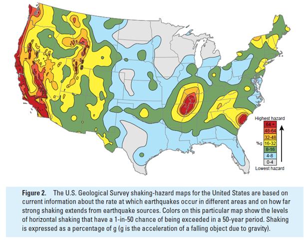
New analyses of the intensity of shaking of the New Madrid earthquakes have resulted in new estimates of the magnitudes of these events (Hough and others, 2000; Hough and Martin, 2002). The revised magnitudes range between M7 to M7.5. More recently (Hough and Martin, 2011), present a revised analysis of the 1811-1812 New Madrid events and state that the magnitude of all of the main earthquakes could be in the range of ~M7. Although these estimated magnitudes are smaller than previous estimates, it is clear that these were very significant events as evidenced by the intensity data (Figures 6-9) and their occurrence indicates a significant earthquake hazard for the Central United States (Figures 10 and 11). Shake maps of the two of the New Madrid events (Figures 8 and 12) and of the October 31, 1895 Charleston, Missouri M6.6 earthquake (Figure 13) have been prepared by Hough (http://pasadena.wr.usgs.gov/office/hough/). The shake maps (Figures 8, 12, and 13) provide good estimates of the intensity of shaking that would be expected upon a future repeat of these earthquakes.
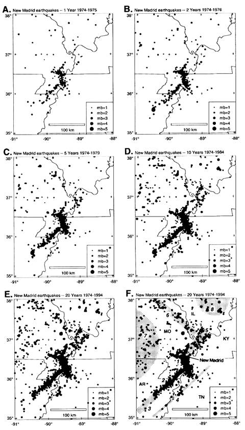
Figure
1. New
Figure
2. Regional Bouguer gravity anomaly map and
1974 – 94 earthquake epicenters (dot size is proportional to magnitude) in the New
Figure
3. Bouguer gravity anomaly map and 1974
– 94 earthquake epicenters (dot size is proportional to magnitude) in the New
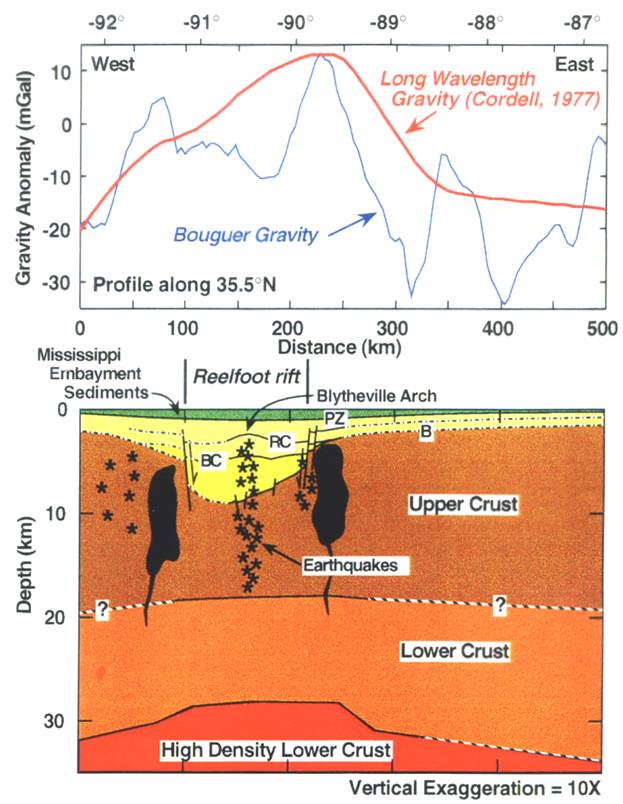
Figure
4. Interpreted crustal model and gravity
data along a west-to-east profile at 35.5 degrees North latitude. The high density lower crust and thinning of
the upper crust are associated with the development of the ancient rift. Subsequently, the area has undergone
substantial subsidence resulting in the deposition of the thick section of
sedimentary rocks in the
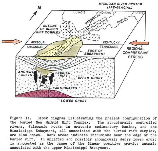
Figure
5. From Braile and others, 1982.
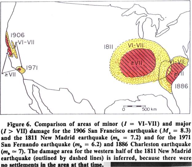
Figure
6. Comparison of Intensity observations
for Central and
Figure
7. Comparison of Intensity observations
for Central US and California earthquakes (http://pubs.usgs.gov/fs/2003/fs017-03/).
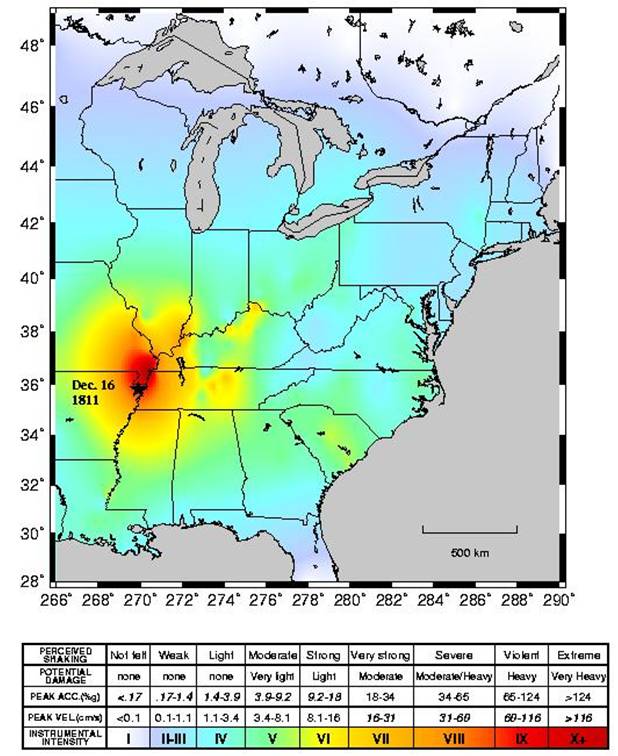
Figure
8. Shake map for the December 16, 1811
New Madrid earthquake (from Susan Hough, http://pasadena.wr.usgs.gov/office/hough/).
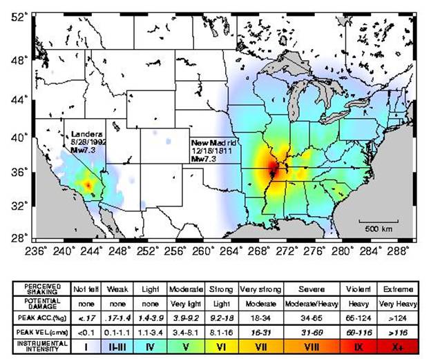
Figure
9. Shake map comparison of the M7.3 New Madrid
and the M7.3 Landers earthquakes earthquake (from Susan Hough, http://pasadena.wr.usgs.gov/office/hough/).
Figure
10. Earthquake hazard map for the U.S. (http://pubs.usgs.gov/fs/2003/fs017-03/).
Figure
11. Earthquake hazard map for the US (http://pubs.usgs.gov/fs/2006/3125/pdf/FS06-3125_508.pdf).
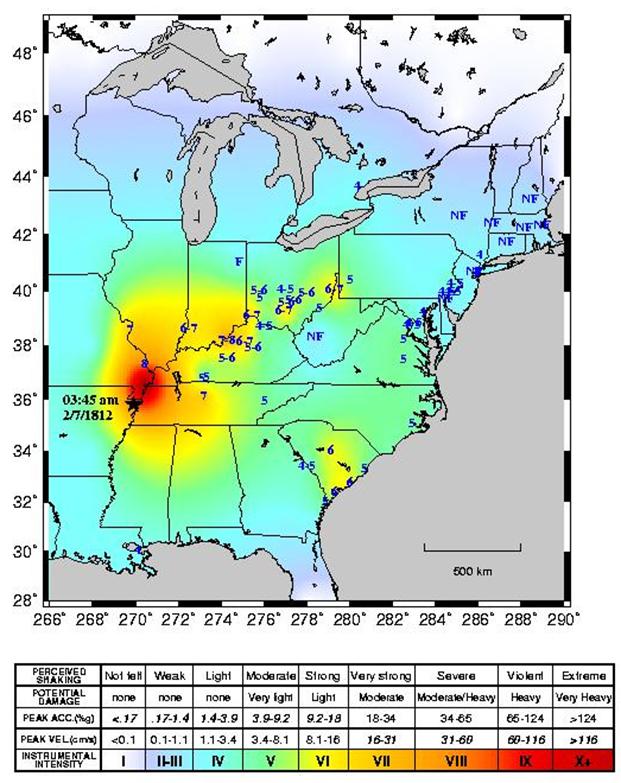
Figure
12. Shake map for the February 7, 1812
New Madrid earthquake (from Susan Hough, http://pasadena.wr.usgs.gov/office/hough/)
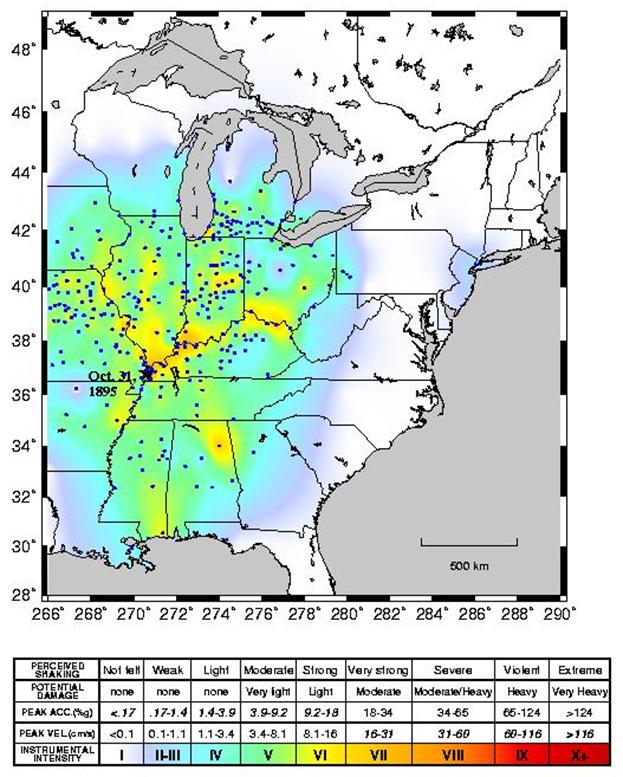
Figure
13. Shake map for the October 31, 1895
M6.6 Charleston, Missouri earthquake (from Susan Hough, http://pasadena.wr.usgs.gov/office/hough/)
References:
Braile,
L. W., G. R. Keller, W. J. Hinze, and E. G. Lidiak, An ancient rift complex and
its relation to contemporary seismicity in the New Madrid seismic zone, Tectonics,
1, 225-237, 1982.
Braile,
L. W., W. J. Hinze, G. R. Keller, E. G. Lidiak, and J. L. Sexton, Tectonic
Development of the New Madrid rift complex, Mississippi embayment, North
America, Tectonophysics, 131, 1-21, 1986.
Braile,
L. W., W. J. Hinze and G. R. Keller, New Madrid seismicity, gravity anomalies,
and interpreted ancient rift structures, Seismological Research Letters,
68, 599 – 610, 1997.
Calais, E., et al. Tectonic strain in plate
interiors? Nature 438, doi: 10.1038/nature04428 (2005),
http://web.ics.purdue.edu/~ecalais/projects/noam/nmsz/nat05/.
Calais,
E.; J.Y. Han; C. DeMets and J.M. Nocquet, (2006), Deformation of the North
American Plate Interior
from
a Decade of Continuous GPS Measurements,
J. Geophys. Res., 111, B06402, doi:10.1029/2005JB004253.
http://web.ics.purdue.edu/~ecalais/projects/noam/jgr06/noam_5.1.pdf.
Calais,
E., and S. Stein, Time-Variable Deformation in the New Madrid Seismic Zone,
Science, 13 MARCH 2009 VOL 323, p. 1442,
http://web.ics.purdue.edu/~ecalais/projects/noam/nmsz/sci09/Calais_Stein_Science_2009.pdf.
Calais,
E; A. M. Freed; R. Van Arsdale; and S. Stein, Triggering of New Madrid
seismicity by late-Pleistocene erosion, Nature,
Vol 466|29 July 2010| doi:10.1038/nature09258,
http://web.ics.purdue.edu/~ecalais/projects/noam/nmsz/nat10/Calais_etal_Nature_2010.pdf.
Cordell,
L., Regional positive gravity anomaly over the
Ervin,
C. P., and L. D. McGinnis, Reelfoot rift: Reactivated precursor to the
Hildenbrand,
T., Rift structure of the northern
Hough, S.E., J.G. Armbruster,
L. Seeber, and J.F. Hough, On the modified Mercalli intensities and magnitudes
of the 1811-1812 New Madrid earthquakes, Journal of Geophysical Research,
23,839-23,864, 2000.
Hough, S.E. and S. Martin
(2002). Magnitude estimates of two large aftershocks of the
Hough, S.E. and M. Page,
(2011), Toward a consistent model for strain accrual and release for the New
Madrid Seismic Zone, central United States, Journal of Geophysical Research,
VOL. 116, B03311, 17 PP., 2011
doi:10.1029/2010JB007783, http://www.agu.org/pubs/crossref/2011/2010JB007783.shtml.
Johnston,
A. C., A major earthquake zone on the Mississippi, Scientific American, 246,
59 – 68, 1982.
Johnston,
A. C., and E. S. Schweig, The enigma of the New Madrid earthquakes of 1811 –
1812, Annual Reviews of Earth and Planetary Sciences, 24, 339 –
384, 1996.
Nuttli,
O. W., The Mississippi valley earthquakes of 1811 and 1812, intensities, ground
motion, and magnitudes, Bulletin of the Seismological Society of America,
63, 227 – 248, 1973.
Zoback,
M. D., R. M. Hamilton, A. J. Crone, D. P. Russ, F. A. McKeown, and S. R.
Brockman, Recurrent intraplate tectonism in the New Madrid seismic zone, Science,
209, 971-976, 1980.
http://pasadena.wr.usgs.gov/office/hough/ (Information on recent studies of the New
Madrid earthquakes, links to updated intensity maps and contemporary accounts
of the New Madrid earthquakes).
A
color version of this document is available online at www.eas.purdue.edu/~braile (click
on News).
Central U.S. Earthquakes Information (L. Braile, April 18, 2011)
Information for the Central U.S. Great Shakeout
Seismic Sleuths (can download pdf): http://www.fema.gov/library/viewRecord.do?id=3558
Tremor Troop (Earthquake) (can download pdf): http://www.fema.gov/pdf/library/tremortroop.pdf
Get your schools ready and involved in the “Great Shake Out”
http://www.theindychannel.com/news/27449973/detail.html?taf=ind
USGS Earthquake Preparedness Web Page: http://earthquake.usgs.gov/learn/topics/?topicID=25
Central US Putting Down Roots in Earthquake Country (can download pdf): http://pubs.usgs.gov/gip/119/
Central US Earthquake Guide (can download pdf): http://www.cusec.org/publications/safety/earthquakeguide_lowres.pdf
Elected Officials Guide to Earthquakes in the Central US (can download pdf): http://www.cusec.org/publications/planning/electedofficialsguide.pdf
Indiana Great Shakeout Page: http://www.in.gov/dhs/3536.htm
EQ video for kids: http://www.youtube.com/watch?v=DmYcmpK31wI&feature=youtu.be&safety_mode=true&persist_safety_mode=1
EQ video: http://www.youtube.com/watch?v=YfaGlzhsxjI&feature=youtu.be&safety_mode=true&persist_safety_mode=1
Central US Great Shakeout: http://www.shakeout.org/centralus/
New Madrid Bicentennial: http://newmadrid2011.org/
Shakeout Video on YouTube: http://www.youtube.com/watch?v=6Rjyt7XAZrA&feature=player_embedded#at=173
Shakeout Video on Shakeout Page: http://newmadrid2011.org/index.php?option=com_content&view=article&id=75:new-shakeout-video-available&catid=11&Itemid=25
Central US EQ Map: http://pubs.usgs.gov/imap/i-2812/
Center for Earthquake Research and Information (CERI, University of Memphis): http://www.ceri.memphis.edu/index.shtml
CERI Great Shakeout Announcement: http://www.ceri.memphis.edu/awareness/shakeout_ceus.html
CERI How to Survive an Earthquake: http://www.ceri.memphis.edu/awareness/survival.html
Drop, Cover, Hold On: http://dropcoverholdon.org/
Arkansas Earthquake Swarm (Guy Earthquake Swarm) Information: http://www.ceri.memphis.edu/GUY/press_030411.html
USGS Poster – Guy Earthquake Swarm: http://earthquake.usgs.gov/earthquakes/eqarchives/poster/2011/20110228.php
USGS Central US Fact Sheets: http://pubs.usgs.gov/fs/2009/3071/; http://pubs.usgs.gov/fs/2009/3071/pdf/FS09-3071.pdf, http://pubs.usgs.gov/fs/2006/3125/, http://pubs.usgs.gov/fs/2006/3125/pdf/FS06-3125_508.pdf
USGS Fact Sheets: http://earthquake.usgs.gov/learn/publications/pubs_factsheets.php